 Guyane-SIG
Environmental monitoring facilities
Type of resources
Available actions
Topics
Keywords
Contact for the resource
Provided by
Years
Formats
Representation types
Update frequencies
status
Scale
Resolution
-

Shom manages a network of permanent digital coastal tide-gauges on French coasts: the RONIM Sea Level Observation Network. Most tide-gauge observatories are partnered with one or more local partners.<br /><br /> Four main types of data are available for download:<br /> - “Raw high frequency" data: raw observations neither validated nor evaluated, obtained directly from the sensor. 1-minute measurement; integration time 15 seconds (on the minute); sampling period: 1 second.<br /><br /> - "Raw non-real time" data: raw observations neither validated nor evaluated, obtained directly from the sensor. 10-minute measurement; integration time 121 seconds (around every 10 minutes); sampling period: 1 second.<br /><br /> - "Validated non-real time" data: observations checked and validated by Shom from the "Raw non-real time" data. 10-minute measurement; integration time 121 seconds (around every 10 minutes); sampling period: 1 second.<br /><br /> - "Validated hourly" data: observations checked and validated by Shom, generated from "Validated non-real time" data. Hourly measurement obtained from the Vondrak filter with triangular weighting. The hourly height cannot be calculated in the event of an observation gap greater than 1.5 hours.
-
Shom is the national referent for the level of the sea in situ on all areas under French jurisdiction. In this capacity, he assures under the acronym REFMAR different coordination functions in the collection and dissemination of public data related to water level observations, in order to promote their use in multiple applications within the framework of international recommendations.
-
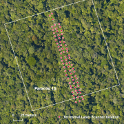
The terrestrial laser scanning (TLS) dataset covers a transect in plot 15 at the experimental station Paracou in French Guiana.
-
The terrestrial laser scanning (TLS) dataset covers the Guyaflux plot 9 of the experimental station Paracou in French Guiana.
-

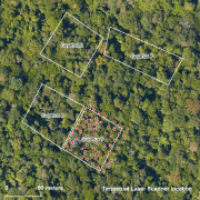
The terrestrial laser scanning (TLS) dataset covers Guyaflux plots 1 and 9 at the experimental station Paracou in French Guiana.
-
The UMR EcoFoG possesses an herbarium reference collection based on samples harvested all along the different forest plots studied by our teams. This collection is maintained by a botanist and stored on the Agronomical Campus of Kourou, INRA building. A Excel database is linked to this collection and the taxa found in it are listed in the Guyafor database. The collection gathers more than 3000 samples representing 74 families, 288 genera and more than 800 taxa.
-

The “Herbier IRD de Guyane” (CAY) was established in 1965 by R.A.A. Oldeman and harbors nearly 200000 specimens, mostly from French Guiana and nearby countries Suriname, Guyana, Brazil (particularly the state of Amapá), and Venezuela (state of Amazonas). The dataset presented here is the fruit of 30-years’ work by CAY’s staff as well as that of numerous other botanists who have helped make CAY a key scientific platform and leading center of botanical research for the Guiana Shield.
-

Environmental DNA metabarcoding has recently emerged as a non destructive alternative to traditional sampling for characterising species assemblages. We here provide a consistent dataset synthetizing all eDNA sampling sites in French Guiana to date. We also provide a taxon by site matrix for fishes presence / absence as inferred from eDNA. Our aim is to allow a transparent communication to the stakeholders, and provide the foundation for a monitoring program based on eDNA.
-

The experimental site of Guyaflux in the Paracou forest (Sinnamary, French Guiana) has been created in 2003 and is set up for at least 20 years. Guyaflux has several aims : 1. to characterise the greenhouse gases exchanges between the forest ecosystem and the atmosphere. 2. to assess the contribution of Guianese tropical humid forest ecosystem to the biospheric carbon sink. 3. to assess the impact of environmental constraints on carbon footprint. 4. to analyze the contribution of different compartments of the ecosystem (soil, subsoil, canopy) to storage and water and carbon flows. 5. to model the primary productivity of this ecosystem by linking carbon flow and tree growth. 6. to assess interactions between water cycle, carbon cycle and major soil minerals (nitrogen and phosphorus) The experimental set-up is composed of a 55m-high flux tower, which measures gases exchanges in real-time.Several data types are registrated : microclimatic data, carbon and water flows between forest ecosystem and atmosphere, CO2, CH4, H2O, water content of the soil, trees growth, evapo-transpiration from the trees...To obtain the flows of water and carbon, the turbulent correlations method is used. The project owner is Institut national de la recherche agronomique (INRA). NORELEC is the master builder of the tower. The Guyaflux project received 55% of its funding by INRA and 45% by Ministry of Research and European Union.
-

Guyafor is a network of permanent forest plots installed in French Guiana. The site of Montagne Tortue covers a 19,2ha area. It is composed of 3 plots managed by ONF. 9210 trees are being followed. 5 campaignes of inventories have been made in 2002, 2005, 2007, 2009, 2010.