 Guyane-SIG
Elevation
Type of resources
Available actions
Topics
Keywords
Contact for the resource
Provided by
Years
Formats
Representation types
Update frequencies
status
Scale
Resolution
-

Bathymetric datasets are an extraction of surveys belonging to the Shom public database. For depth up to 50m, the vertical precision of soundings varies from 30cm to 1m and the horizontal precision varies from 1 to 20m. In deep ocean, the vertical precision is mainly around 1 or 2% of the bottom depth. It is sometimes more, it depends on the technology used. The data are referenced to ZH which is assimilated to LAT. Data are corrected for sound velocity variations.
-
The aerial laser scanning (ALS) dataset, acquired on 20 October 2009, covers the experimental station Paracou in French Guiyana. More precisely, the dataset covers 9 plots totally (Paracou 4, Paracou 5, Paracou 7, Paracou 8, Paracou 9 - Paracou 12, and Paracou 14) and 4 plots partly (Paracou 3, Paracou 6, Paracou 13, and Paracou 15). The area includes exploited and non-exploited forest and Pinot palm.
-
The aerial laser scanning (ALS) dataset, acquired on 11 September 2009, covers the experimental station Paracou in French Guiana. More precisely, the dataset covers 9 plots totally (Paracou 4, Paracou 5, Paracou 7, Paracou 8, Paracou 9 - Paracou 12, and Paracou 14) and 4 plots partly (Paracou 3, Paracou 6, Paracou 13, and Paracou 15). The area includes logged-over and unlogged forest, various forest heights and Pinot palm swamp forest .
-
The aerial laser scanning (ALS) dataset acquired on 23 September 2013 covers the experimental station Paracou in French Guiana. The coverage includes all Guyafor and Guyaflux plots completely with logged-over, unlogged and swamp forest ("Pinot" or "Açai").
-

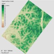
The aerial laser scanning (ALS) dataset, acquired on October 2004, covers the experimental station Paracou in French Guiyana. More precisely, the dataset covers all Paracou plots totally except of plot 15 that is only covered partly. The area includes exploited and non-exploited forest and Pinot palm. Ground echoes are available as well as a digital terrain model (DTM), a digital surface model (DSM) , and a digital canopy model (DCM) with a 1 meter resolution.
-

The aerial laser scanning (ALS) dataset, acquired in 2004, covers the Macouria area in French Guiana.
-

The aerial laser scanning (ALS) dataset acquired on 26th September 2011 covers part of the Paracou experimental station in French Guiana. Plots entirely covered include Paracou 4, 5, 7, 8, 9, 10, 11, 12, and 14. Plots 3, 6, 13, and 15 are partially covered by the data. The area includes both natural unlogged forest and logged over forest.