 Guyane-SIG
dataset
Type of resources
Available actions
Topics
Keywords
Contact for the resource
Provided by
Years
Formats
Representation types
Update frequencies
status
Scale
Resolution
-

One mosaic of 16 map sheets: 1. Ressources en sols de Guyane : esquisse des unités agronomiques déduites des cartes pédologiques : Cayenne (N.O.). Scale of 1:100 000. Date of publication: 1975. 2. Ressources en sols de Guyane : esquisse des unités agronomiques déduites des cartes pédologiques : Cayenne (S.O.) - Roura. Scale of 1:100 000. Date of publication: 1975. 3. Ressources en sols de Guyane : esquisse des unités agronomiques déduites des cartes pédologiques : Haut-Kourou (N.E.). Scale of 1:100 000. Date of publication: 1975. 4. Ressources en sols de Guyane : esquisse des unités agronomiques déduites des cartes pédologiques : Kourou - Sinnamary. Scale of 1:100 000. Date of publication: 1975. 5. Ressources en sols de Guyane : esquisse des unités agronomiques déduites des cartes pédologiques : Mana - Saint Laurent (S.E.). Scale of 1:100 000. Date of publication: 1975. 6. Ressources en sols de Guyane : esquisse des unités agronomiques déduites des cartes pédologiques : Mana - Saint Laurent (S.O.). Scale of 1:100 000. Date of publication: 1975. 7. Ressources en sols de Guyane : esquisse des unités agronomiques déduites des cartes pédologiques : Organabo - Iracoubo. Scale of 1:100 000. Date of publication: 1975. 8. Ressources en sols de Guyane : esquisse des unités agronomiques déduites des cartes pédologiques : Régina (N.E.). Scale of 1:100 000. Date of publication: 1975. 9. Ressources en sols de Guyane : esquisse des unités agronomiques déduites des cartes pédologiques : Régina (N.O.). Scale of 1:100 000. Date of publication: 1975. 10. Ressources en sols de Guyane : esquisse des unités agronomiques déduites des cartes pédologiques : Régina (S.E.). Scale of 1:100 000. Date of publication: 1975. 11. Ressources en sols de Guyane : esquisse des unités agronomiques déduites des cartes pédologiques : Régina (S.O.). Scale of 1:100 000. Date of publication: 1975. 12. Ressources en sols de Guyane : esquisse des unités agronomiques déduites des cartes pédologiques : région des terres basses entre les fleuves Mahury et Oyapock : Cayenne - Régina : carte. Scale of 1:100 000. Date of publication: 1975. 13. Ressources en sols de Guyane : esquisse des unités agronomiques déduites des cartes pédologiques : région des terres basses entre les fleuves Mahury et Oyapock : Guisanbourg - Ouanary. Scale of 1:100 000. Date of publication: 1975. 14. Ressources en sols de Guyane : esquisse des unités agronomiques déduites des cartes pédologiques : Saint Jean (N.E.) - Basse Mana (N.O.). Scale of 1:100 000. Date of publication: 1975. 15. Ressources en sols de Guyane : esquisse des unités agronomiques déduites des cartes pédologiques : Savane Matiti. Scale of 1:100 000. Date of publication: 1975. 16. Ressources en sols de Guyane : esquisse des unités agronomiques déduites des cartes pédologiques : Sinnamary - Iracoubo. Scale of 1:100 000. Date of publication: 1975.
-

The map sheet: 1. Carte schématique des stations hydrologiques en Guyane. Scale of 1:2 000 000. Date of publication: unknown.
-

Information layer containing the SAR Zones (Search and Rescue). This layer contains a description of the French search and rescue (SAR) areas and the location of the associated Maritime Rescue Coordination Center (MRCC). it covers the areas of responsibility of France. The layer was produced by the Shom pursuant to the Circular Circular of the International Maritime Organization (IMO No. SAR.8 / Circ.4 of 1 December 2012).
-

Mosaic of 569 aerial photographs. The image covers the area around Paracou in French Guiana.
-
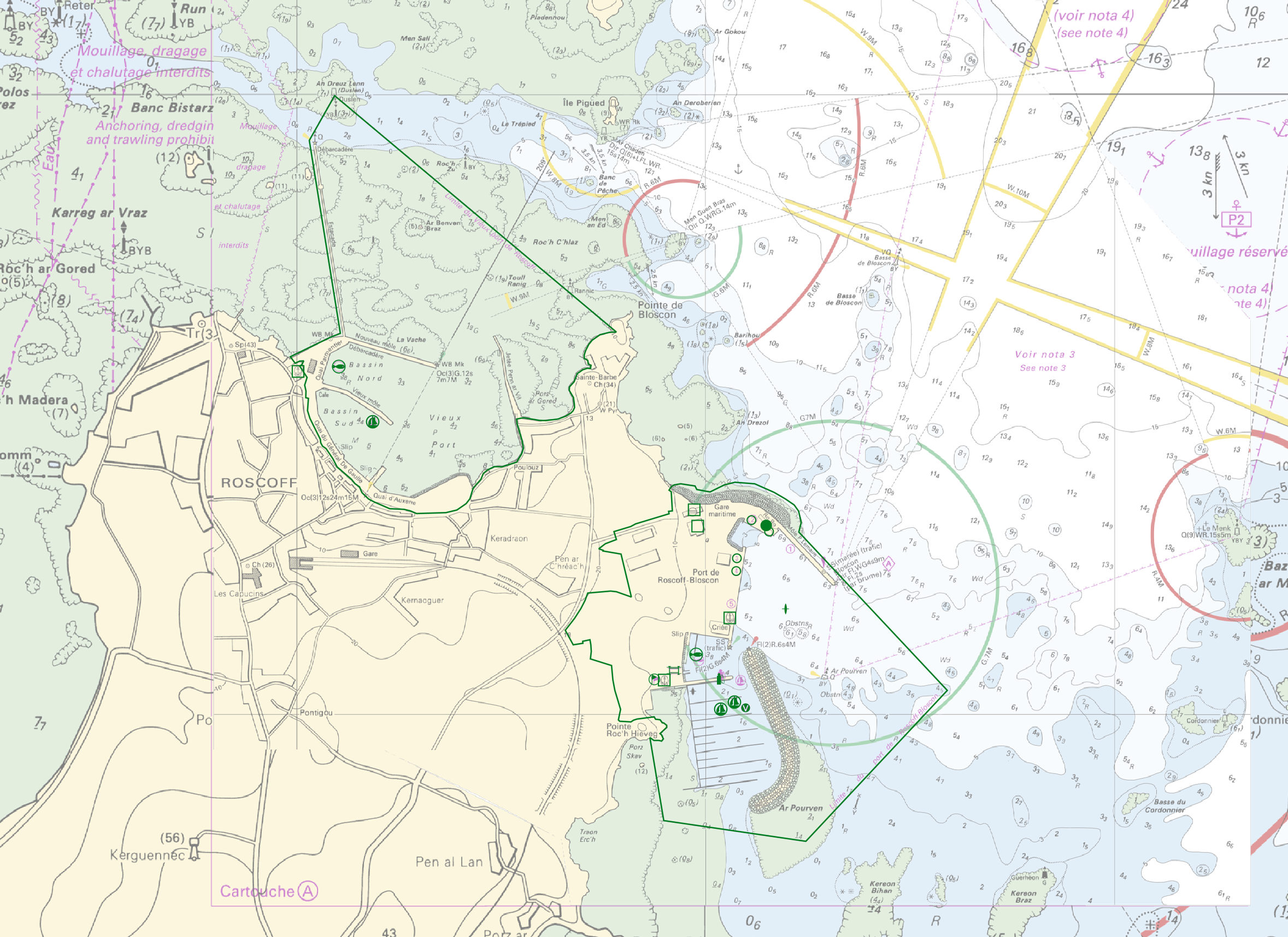
"Harbour Information" product contains 13 object classes, the acronyms used are those of IHO standard S-57 - International Hydrographic Organization – (https://iho.int/): - Berth (BERTHS): place in which a ship is moored at wharf - Isolated building localizing a harbour office (BUISGL) - Checkpoint (CHKPNT) - Crane (CRANES) - Floating dock (FLODOC): floating structure of one or more sections which can be partly submerged by controlled flooding to receive a vessel, then raised by pumping out the water so that the vessel's bottom can be exposed for maintenance. - Gridiron (GRIDRN): structure in the intertidal zone serving as a support for vessels at low tide to permit work on the exposed portion of the vessel's hull. - Harbour area (HRBARE) : administrative area of a port, including all docking and handling facilities, as well as short-term storage facilities. - Harbour facility (HRBFAC) - Hulk (HULKES) : hull of a wrecked or condemned ship, from which the fittings and superstructure have usually been removed, which is moored in a permanent position or grounded. - Oil barrier (OILBAR) - Pilot boarding place (PILBOP) - Rescue station (RSCSTA) - Small craft facility (SMCFAC) Detailed definitions of each of these object classes can be found in the S-57 standard (https://iho.int/en/standards-and-specifications). An online catalog is available at http://www.s-57.com/. Some of the symbols used for display on data.shom.fr portal have been adapted from icons from the OpenSeaMap open library (https://github.com/OpenNauticalChart/).
-
Subset of the image that covers the area around Régina in French Guiana.
-

Subset of the Pléiades image that covers a small area near Régina in French Guiana.
-

Subset of the Pléiades image that covers a small area south of Régina in French Guiana.
-

Subset of the Pléiades image that covers the area near Saint Georges in French Guiana.
-

Subset of the Pléiades image that covers the experimental station Paracou in French Guiana.